Route
I've taken a starting point for this walk of the west side of Ballater Old Railway Station where there is this board (below), erected by the Upper Deeside Access Trust. The walks shown on the board include many of the walks on this website, including this one, although I've suggested a slightly longer walk to the one shown. My version has a different route down and hopefully some really great views.
 |
| The walk begins at this board erected by the Upper Deeside Access Trust |
From the board walk along the front Ballater station. To the east the station is a passageway that leads to the old railway line. When you arrive at the railway line walk along it (you can only go one way) which will be east.
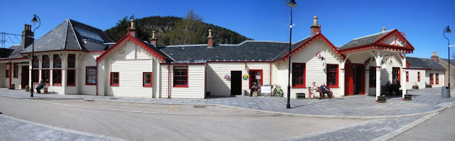 |
| Walk past Ballater station, through the passageway on your left and then along the old railway line. |
Walk along the old railway line for a short distance. There a number of paths leading off to the left. Take one. It doesn't really matter which. Here is one pictured below. The one I've suggested on the map is a short distance after this.
 |
| Take one of the paths off to the left. |
Whichever turn you take, you'll come out onto Provost Craig Road. Off to your left will be the village green where the annual highland games are held. To the left of this a path leads under some trees (just to the right of the red fence in the photo below). Take this path.
 |
| Take the path to the right of the red fence |
Here's a close-up of the path:
 |
| The path leads along the side of the village green. |
Walk along the path under the trees. Another path will cross it but keep going.
 |
| Ignore paths crossing from the left or right |
The footpath continues roughly east, past fields on your right.
 |
| The path passes fields on the right. |
After a couple of hundred yards the path bends to the left and into a little cul-de-sac called Morven Way. Keep going in the same direction and it will come out into a road, which is the B972 the Pass of Ballater.
 |
| The path opens out into a road. Go straight ahead. |
Turn right on the Pass of Ballater. You will see a road sign that says "Tullich". Walk along the Pass of Ballater looking out for traffic.
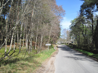 |
| Turn right on the road and pass the "Tullich" roadsign |
You pass a power sub-station. After a short further distance there is a lay by with space for a car to park on the left with a path leading off up the hill. If you want to shorten the walk you can drive to this spot and leave the car here.
Take the Landrover track that leads off to the left up the hill. Sometimes if there is forestry work going on you'll see a warning sign. In my experience provided you stay on the track there will be no problem.
 |
| Take path to the left at the layby. |
Follow the Landrover track up the hill. You'll pass a "ride" - a break in the trees - with telephone lines. Keep going.
 |
| Follow the Landrover track past the telephone lines |
Another Landrover track leads off to the right. Ignore it and keep following the Landrover track that leads gently up the hill.
 |
| Ignore the turning to the right, keep going up the hill |
The track continues for some distance curving round to the left up the hill. The trees thin out.
 |
| The path climbs around the hill. |
Eventually you come out of the trees. Crannach Hill is to the right. Ahead of you is Morven (871m).
 |
| Ahead of you is Morven. |
The Landrover track now curves round so that you are heading back west, continuing to climb Creagan Riabhach. Soon the path arrives in the saddle between two peaks. The path branches. Take the path to the right. However, if you want to see the antennae and a view across the Dee valley, you may want to take the path to the left first. I've marked the left fork in light blue on the map above.
 |
| Take the right fork, but you can go left first if you like |
If you take the left hand fork
If you do take the left path first to see the antennae you'll pass this pond (below) to one side.
On a clear day the crags you can see behind the pond are the crags of Carn Mor (1150m). There is a loch at the base of the crags, Lochnagar (it's one word - don't ask me why), and as a result everyone calls the crags "Lochnagar". They are about 14 miles away.
 |
| The mountain in the distance is Lochnagar |
The left hand fork leads to an antennae which is what you can see from Ballater village.
 |
| The lefthand fork ends at an antennae |
From the foot of the antennae is a good view of the valley. The snow covered peak to the right is Mount Keen (939m), about 8 miles south.
 |
| From the antennae you can see Mount Keen to the south. |
The right hand fork
By now you should either have been to the antennae and back or should have taken the right hand path at the fork.
Once you have taken the right fork bear right again to head up the hill. You may see another track in the heather going straight on - ignore this.
 |
| After taking the right hand fork in the Landrover track bear right up the hill. |
Now you are climbing up to the summit of Creagan Riabhach itself, 533m above sea level. As you continue to follow the path the trees will thin out. You may spot less well defined tracks off to either side - ignore them, keep on the same path, which for now will be taking you up the hill, away from Ballater.
 |
| The trees thin out as you reach the top of Creagan Riabhach |
The top of Creagan Riabhach is quite flat, here's a photo of it below. This is taken looking back i.e. not the way you should be going, so don't get confused - you should still be walking away from Ballater at this point.
In this photo Mount Keen is the snows-covered peak to the left. Ballater is in the centre and Craigendarroch is on the right.
 |
| Looking back, Mount Keen is to the left, the village of Ballater and Craigendarroch are on the right. |
Keep following the path along what is essentially now a plateau, with great views on both sides on a clear day. Below is a photograph of the view to the left - Lochnagar in the distance.
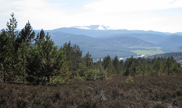 |
| Lochnagar from the top of Creagan Riabhach |
For the last 500m or so you will have been walking almost directly away from Ballater. You may see some other paths around you. Don't worry, when you get to the right junction you can't miss it.
Before long you'll come to a junction in the Landrover track (below). Take the left hand track - which leads directly back towards Ballater.
 |
| Turn left when you come to the junction in the paths. |
You can't see Ballater at first but may make out Mount Keen in the distance. Take this path:
 |
| After going left at the junction the path leads back south, you may see Mount Keen in the distance. |
The path leads down the hill and into a wood:
 |
| The path leads into a wood. |
Walk through the wood, shortly the path comes out the other side and continues to descend the hill.
 |
| Keep following the path down the hill. |
Now the path runs alongside the Lorn Burn. To your right is Balmenach farm and somewhere beyond it is the ruins of Abergairn Castle. Ahead of you is the back of Craigendarroch.
 |
| Keep following the path back towards Craigendarroch Hill. |
During the walk don't be surprised if you see prints like these (below) in the soil. They are from the hooves of deer that are common in the hills.
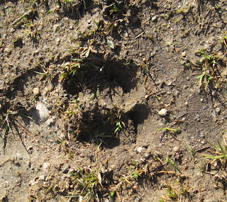 |
| The distinctive two semi-circles of a deer's hoof print. |
The path flattens out then crosses the Lorn Burn (below).
 |
| Cross the burn and bear to the left. |
There is a final hundred yards though the trees before path emerges back onto the Pass of Ballater (the B972).
If you left your car at the car park on the Pass of Ballater then turn left here and walk along the Pass of Ballater to return to it (marked in light blue on the map).
If you walked all the way from the old railway station then turn right. I'll show you a different way to get back to Ballater.
 |
| The path joins the Pass of Ballater. Turn right for the carpark, left for Ballater village |
For those who have turned right, follow the road around Craigendarroch.
 |
| The Pass of Ballater leads around Craigendarroch. |
Soon you'll come to the junction between the Pass of Ballater and the main A93 Braemar Road. I haven't got a photo to illustrate what to do when you get to the A93 so let me try and explain carefully:
When you get to the A93 (the Braemar Road) cross over that road. Turn right. Only a couple of metres away is a break in the fence. There is a footpath leading downhill to the old railway line.
Go through the break in the fence and follow the footpath down to the old railway line.
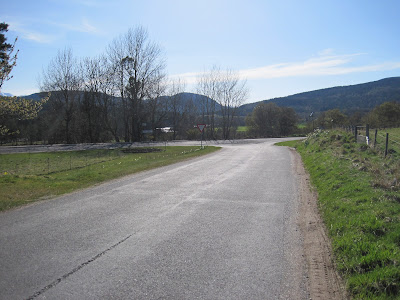 |
| Cross the main road and go through the gap in the fence at the far side. Follow the footpath downhill to the old railway line. |
When you reach the old railway line (now a wide footpath) turn left and walk towards Ballater. The River Dee should be on your right, on the far side of some fields.
"Polvier" - HM Queen Elizabeth The Queen Mother's fishing hut
Not long after you have started walking along the old railway line you should see a wooden fishing hut across the water. This is "Polvier", the late fishing hut favoured by HM Queen Elizabeth The Queen Mother when she was staying at Balmoral.
 |
| "Polvier", HM Queen Elizabeth The Queen Mother's fishing hut |
Continue to follow the old railway line down river for 200 yards or so back into Ballater village.
 |
| Walk along the old railway line. The river should be on your right. |
The old railway line meets a road. The photograph below is taken looking back the way you have come. Keep going straight on along the road which is Old Line Road, into Ballater.
 |
| Continue going straight when the old railway line meets a road. |
Walk along Old Line Road. It will go round a corner to the left and rejoin the main Braemar road. Don't follow the Old Line Road round the corner. Instead there is a footpath straight ahead - take it.
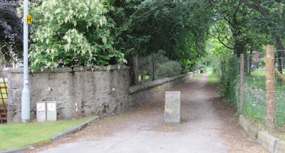 |
| Don't go round the corner - follow this foot path to Dundarroch Road instead. |
The foot path comes out onto Dundarroch Road. At the end of Dundarroch Road turn left onto Invercauld Road.
 |
| From Dundarroch Road turn left onto Invercauld Road |
Walk up to the main road. You should emerge by "The Auld Kirk" church. Turn right on the main road and walk back to the station square where you started from.
Congratulations, you have finished the walk up Creagan Riabhach!


